


Historical Urban Planning in Oldtown
August 21, 2023by Bill Tilson
Hispanic Heritage Month is coming up September 15-October 15, 2023. The Museum will celebrate its bi-annual event “Fiesta de Santa Maria” on September 30 from 9-12 at the Downtown Farmers Market on North 7th Street featuring Spanish guitar music, a Flamenco dancer, performances by local dance troupes, food, and visits by costumed historical figures. With the upcoming festivities, it’s also a good time to look back at the origin and influence of Spanish town planning principles on Old Town, the original settlement of Fernandina.
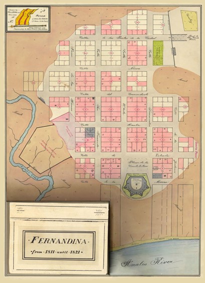
A map of the layout of Oldtown.
Old Town was placed on the National Registry of Historic Places in 1990 as the last town platted in the Western Hemisphere from 1811-1821. The nomination form notes that although no structures remain from the period of record, it is a textbook example of the “Laws of the Indies”, established in 1573 by the Spanish monarch Phillip II. This body of laws created for the government of Spain’s colonies outside Europe (chiefly in the Americas) contains 148 guidelines for urban planning, which many scholars have said were the first wide-ranging guidelines towards design and development of communities.
These guidelines were developed in response to the rapid creation of settlements throughout the Americas, beginning with Isabela, the first permanent Spanish settlement in the New World, which was founded by Columbus in 1493 on Hispaniola (now an archaeological site on the north coast of the Dominican Republic). From there, Spanish settlers quickly overran the island and spread to Puerto Rico in 1508, to Jamaica in 1509, and to Cuba in 1511. Isabela was only inhabited for five years. Disease, overwork, indigenous hostilities, food shortages, and mutinies occurred almost immediately and it was abandoned when Santo Domingo was established in 1496-1497. Panamá Viejo, founded in 1519 by the conquistador Pedrarías Dávila, is the oldest European settlement on the Pacific coast of the Americas and exhibits the European idea of a planned town.
Many settlements in the Americas were established before the town planning principles drawn up by Phillip II were in place, although many still employed gridded layouts. This was because conquistadors, priests, and scholars in these settlements were familiar with examples of the “ideal” city plans found throughout Europe and the Mediterranean. For example, the Roman colonial town of Timgad in present-day Algeria was founded by the Emperor Trajan around 100 CE and is widely regarded as one of the best extant examples of the grid plan as used in Roman city planning. Timgad and other Roman military settlements known as castrum were usually constructed on a square plan oriented to the cardinal directions. Castrum were established by Julius Caesar throughout the Roman Empire. Castra, anglicized as “Chester”, appears in English city names that recall the castrum built at places such as Winchester and Manchester. Other examples of European “ideal” town plans included medieval bastide plans (e.g. Montpazier in France) and Renaissance cities like Sabbioneta in Italy. As the Franciscan scholar Eiximenis wrote in the 14th century: “Every beautiful city should be square: because like that it is more beautiful and more ordered”.
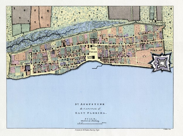 A map of the layout of St. Augustine.
The plan of St. Augustine, Florida is more irregular than the Old Town grid, given that St. Augustine was a more populated town before the 1573 planning laws were implemented. The urban pattern of roads and land parcels that changed over the years after fires, attacks by the English, pirates, and filibusters from the United States are still embedded in the city plan. Fernandina was inhabited by Europeans from the 16th century onward but grew slowly, in a haphazard manner antithetical to the monarchy’s desire for settlements to embody the “order of the empire”. In 1811, Governor Enrique White tasked George J.F. Clarke, Surveyor General, with implementing a town plan that demonstrated a strict adherence to the Law of the Indies established over 200 years earlier.
The Old Town layout consists of blocks divided by equal-width streets running north-south and east-west. Each block is divided into lots of 2 types: peonias and media-peonias, the latter which are unique to Old Town. The dimensions of the lots were not arbitrary and reflect the emphasis on landholders supporting themselves and the community with food and shelter. For example, Rule number 104 of the Laws states: “A peonia is an urban lot 46 feet wide and 92 feet deep, land that will yield 156 bushels of either wheat or barley, 15.6 bushels of corn, land sized for two days of plowing for a vegetable garden, land sized for eight days of plowing to plant unirrigated trees, and pasture land for ten fertile sows, twenty cows, five mares, one hundred sheep, and twenty goats”. The below photograph of Old Town from the late 19th century still shows extensive agriculture on many lots. Nowadays, this practice is a distant memory.
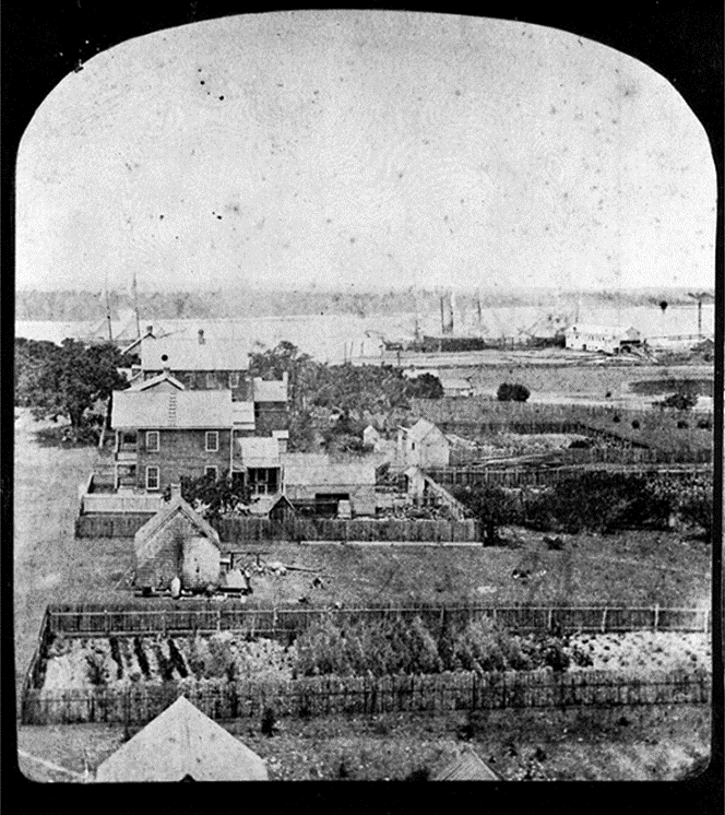 A photograph of Oldtown in the 19th Century.
The original plaza, which is now a State Park, faces the deep waters of the Amelia River as prescribed by the Law of the Indies. The fortification seen in the early plan of Old Town was abandoned after Florida became US territory in 1821, and today, archeological remains only exist below ground. The town languished over the decades and continued to decline when David Yulee established a railroad junction further south in his planned city of New Fernandina. Taking advantage of the deep-water port and easy access to the Atlantic Ocean, Yulee’s plan led to the Golden Age of Fernandina in the late 19th and early 20th century. Old Town remained as a home for ship captains, fishermen, factory workers, immigrants, and old Spanish families like the Traeyes. And yet, the grid remains protected in a set of design guidelines established in 1999 and updated in 2021.
Coincidentally, Old Town’s grid plan was implemented in 1811—the same year the New York City Planning Commission presented its gridded plan for New York City, writing it combined “beauty, order, and convenience.” This New York plan influenced Yulee’s vision for “New Fernandina”, which was drawn up in 1857.
Consider taking a trip up North 14th Street to Old Town—relax on a bench in the plaza and reflect on the site’s deep, complex history.